


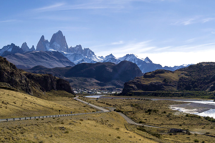
EL CHALTÉN (Argentina), Jan 10 — The drive from the airport to El Chaltén takes us all of three hours but we hardly notice the time. The vistas along the way are too magnificent for us to mind; if anything, we wish the drive took longer.
The clearest sky, a brilliant azure we hardly see anywhere else. The harsh and arid steppe, stretching ever more. The endless winding road, taking us deeper and deeper into the heart of the Southern Argentine mountain range.
The jagged mountain peaks are threatening and inviting at the same time, issuing us a challenge we know we shall attempt to answer the next day. Now it is already past midday and we’re still en route to El Chaltén, the fabled Argentine capital of trekking.
Given its location at the foot of Cerro Chaltén, there is little wonder this is true. The Chaltén towers over all other mountain peaks at a height of 3.4 kilometres. You can see its distinctive gnashed-tooth silhouette from miles and miles.
We certainly do, even from the road. What a call to adventure — terrifying and exciting in equal measure.

The mountain is also known as Monte Fitz Roy, named in honour of Robert FitzRoy, the captain of HMS Beagle who had charted much of the Patagonian coastline and navigated the Santa Cruz River in 1834.
We are in the middle of nowhere yet in some way it feels as though we’ve barely entered Patagonia. The landscape that surrounds us is mythic in dimensions; we are happily overwhelmed.
As we enter El Chaltén, we observe many visitors already returning from their day’s trek. The town is a favourite of skiers in winter and swarmed by hikers all throughout the year.
Though “swarmed” might be overstating it a bit; part of the appeal is the sense of solitude you get on some of the trails when you could easily go for hours without seeing a single other soul.
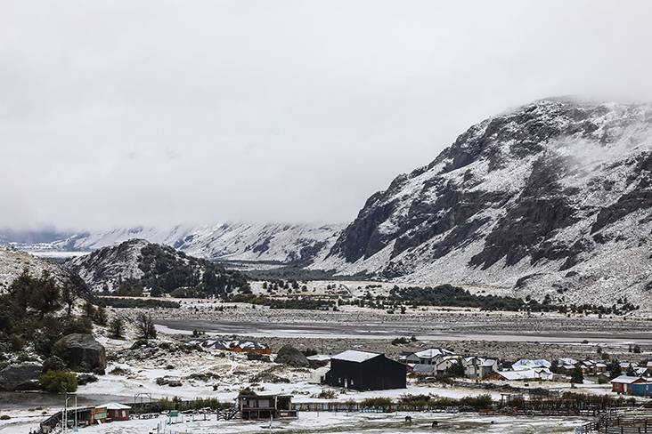
The next day, we wake up to even heavier snowfall that occurred while we slept. Sudden frost leaves both lavender and rose blossoms with an icy coat. Pristine and pretty, like poetry frozen in time.
Our walk begins as an easy stroll, as though we are out to buy some groceries from one of the supermarkets along San Martin, El Chaltén’s main street. Soon the paved streets of the town give way to gravel paths and houses grow sparser in number.
Before we know it, we are at the foot of the mountain. Even here, there is plenty of snow. And above us, mists hover around the mountain peaks like smoke. Indeed, the name Chaltén comes from an indigenous Tehuelche word meaning “smoking mountain”. Cerro, however, is Spanish in origin; it means “hill.”
Like Orpheus who went down to the underworld to rescue his wife Eurydice, we can’t help but turn back. We see the town disappearing in the distance, swallowed by the mountains and mists — the way poor Eurydice must have when Orpheus lost faith and looked back.
We take heed of the folly of the son of Apollo and we press on, only looking forward.
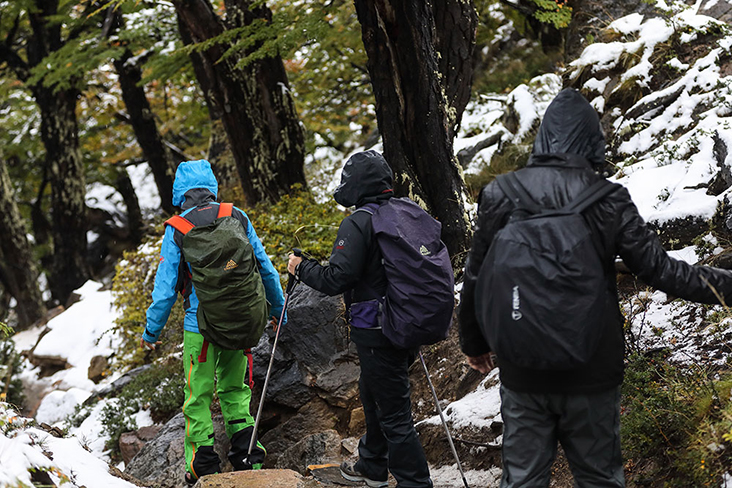
More often than not, the path is almost hidden by the heavy snowfall. On narrower trails, hiking in single file is the way to go. We keep everyone in sight and ensure a steady grip, a firm footing, before taking our next step.
Weather in Patagonia is unpredictable at best, treacherous at its worst. We come prepared to stop for hours if need be. Any optimistic weather forecast is taken with a pinch of salt. You can see why heading out with an experienced guide can be helpful, even for veteran hikers, for only locals know the lay of the land.
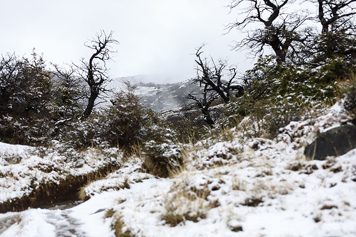
And this land keeps going up, steeper and steeper, with no end in sight.
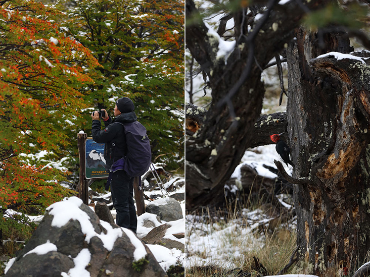
So we take breaks and rest. Or truth be told, make use of the opportunity to take pictures of the ethereal landscape around us — all fog and snow, rivers and waterfalls.
Most of the trees are native lenga, a species of Southern Andean beech. We spot a Magellanic woodpecker — impossible to miss with its crimson head — on one of the trees, hammering away and occasionally calling out, a hoarse and shrill chirp.
Other than that, there is no other sound, no other animal. Just snow and more snow.
Many of the names we encounter here, be it signposts or names of peaks, are courtesy of the European and Argentine explorers. The Spanish explorer Antonio de Viedma was the first European on record to have seen the mountain in 1783.
Over a century later, the Argentine explorer Francisco Moreno named the mountain after the aforementioned Captain Robert FitzRoy on March 2, 1877. Almost another century passed before French mountaineers Lionel Terray and Guido Magnone scaled the mountain in 1952.
Yet they are far from the very first to have observed the great mountain. That honour belongs to the indigenous people of the land – Tehuelche peoples, nomadic hunters who lived in this part of Patagonia centuries ago.
Still, it is always the conquistadors and the colonists who control the narrative, no?
We are neither explorers nor conquistadors. We may have joked about conquering the mountain but in truth, we are simply grateful the mountain hasn’t conquered us, hasn’t chewed us up and spit us out.
The mountain is formidable; the men who climb it, less so.
After an hour and a half of cutting through the lenga forest and following the course of the Fitz Roy River, we arrive at the Mount Torre viewpoint. The fog, as if on cue, finally clears. The advertised views don’t disappoint: the stunning Adela range and the iconic Mount Torre, capped with rime ice.
What a day it has been!
There is an unmistakable sense of accomplishment. We have gone much further than we had ever imagined, being city folk. We share our elation with our guide. She grins, then deflates us with a single remark: “Oh, this is just a warm up. There’s more to come.”
Ah, well. Baby steps. At least we have come this far.
Yes, baby steps. It’s a start.
Getting there
The easiest way to reach El Chaltén is to first arrive by plane at the El Calafate International Airport (Comandante Armando Tola International Airport). Most of the flights arrive from Buenos Aires; a direct flight would take approximately three hours. From the El Calafate International Airport, it’s another 222km to El Chaltén over fully paved roads. Buses cost 800 Chilean pesos (RM4.15) one way; private transfers can usually be arranged with one’s accommodation at El Chaltén as well.


