


SINGAPORE, March 12 — Singapore may still be years away from drone deliveries and flying taxis, but the successful conclusion this week of a two-year trial for a traffic management system able to plan and track hundreds of drone flights puts the Republic one step closer to that reality, its creators said.
On Wednesday (March 10), testers from engineering services firm Nova Systems and air operations company OneSky completed a live demonstration of their Unmanned Aircraft System Traffic Management, or UTM for short, for Singapore’s civil aviation authorities.
It is essentially the equivalent of the software used by an airport’s control tower, except that it caters for low-flying unmanned drones.
The project was co-funded by the Transport Ministry (MOT) and the Civil Aviation Authority of Singapore (CAAS) in 2018. If adopted, the UTM system could make possible large-scale drone deployments, such as delivering Covid-19 test kits to ship crews, or even flying cars, eventually.
Three drones — including an ST Aerospace hexacopter with six whirling blades powered by a 5G cellular network — took flight from Marina South Pier in front of the authorities, following pre-planned routes that took them far out to sea.
Tan Kah Han, CAAS’ senior director of its unmanned systems group, said the outcome of the demonstration will help the authorities pursue more efficient ways to safely manage drone traffic at scale in Singapore.
“This is important as Singapore’s limited and congested airspace requires creative solutions to manage the risk posed by unmanned aircraft operations,” said Tan.
Ryan Lee, Nova’s managing director Asia, said of his consortium’s prototype: “In about two years’ time, we should be ready to deploy three or four unmanned aircraft in the same area of operations at the same time. By 2030, air taxis could become a commercially viable reality.”
How it works
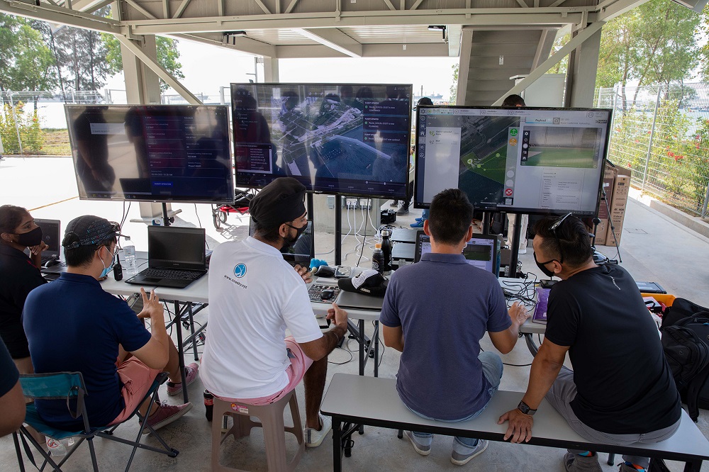
On Tuesday, the Nova and OneSky consortium gave a live demonstration to reporters of how it all works, showcasing the UTM system’s ability to process flight plans and manage aerial drone traffic quickly and seamlessly.
At present, planning drone flights is a “manual process” of submitting documents via email to the CAAS for approval — a procedure that requires the authorities to labouriously figure out whether the flight route comes into conflict with other air traffic or no-fly zones, explained Nova’s head of business development Sanjay Suresh in a run-through of the system.
The approvals process can also take five to 10 days, he said.
“In a nutshell, drone operators tell the authorities the location and the time of the flight, and the authorities draw a black box (on the map) marking out where the drone will fly. And if another person asks for permission to fly in that black box and in that time, it gets denied.
“But the authorities cannot track and see where the aircraft is. The poor officer has to call to check if he wants to know whether the flight is over,” said Suresh.
This is not ideal for a future where hundreds of drones are expected to be criss-crossing Singapore’s airspace at the same time, performing various tasks.
Nova’s UTM allows drone pilots to file digital flight plans to the CAAS, and the system is able to harness data analytics to automatically figure out if the newly submitted flight plan is safe to fly.
Besides preventing mishaps such as mid-air collisions or air space violations, the UTM system can also react to quickly developing situations such as bad weather, wind tunnelling effects, and birds, which is a problem as some birds are known to attack smaller drones.
Currently, it can manage around 500 drone flights simultaneously, far more than the number of these aircraft in the air today at any one time, said Suresh.
Location data from the drones is also beamed back to the system, allowing drone pilots as well as the authority to monitor in real-time where the drone is at any given time.
Still a work in progress
Suresh said this potentially allows the businesses and the general public to track drone flights too via a mobile phone application, which is still undergoing development.
This feature is similar to flight radar apps that are already available for civilian airplanes, he said.
In future, it could allow residents to find out why a drone is being flown in their neighbourhood, and could open up more advanced possibilities such as allowing a person to see whether his drone-delivered parcel is on its way, said Suresh.
With the conclusion of this week’s demonstrations, Nova said it has completed a trial that began in October 2018 and was slightly hampered by the Covid-19 pandemic.
That means that Singapore now has a functioning “baseline” drone management system that will need further work to add the unique requirements of any government agency interested in it, said Suresh.
It has successfully tested drones in 12 locations without incident, including commercial and industrial areas as well as residential areas in Robertson Quay and Lavender.
“We wanted to do more tests over Queenstown and other areas, but that was at a point when public perception of drones was low due to the airport incursions (in 2019). There were privacy concerns too,” said Suresh.
“Through our system, the eventual goal is to keep flight routes far from residential areas and no-fly zones.”
Singapore’s autonomous future of flight
Nova’s completed trial is one of four proposals submitted to the CAAS and MOT in 2017 to create a safe and effective package delivery system.
The agencies had called for proposals of unmanned aviation projects to boost the CAAS’ regulatory capabilities, and four projects received 50 per cent funding from the Government of up to S$1.5 million (RM4.5).
Tan from CAAS said: “Given Singapore’s dense urban landscape and evolving unmanned aircraft technology development, close collaboration between government agencies and the industry enables beneficial use of unmanned aircraft, while ensuring public safety, security and social acceptance.”
The other projects include a maritime service to consolidate various delivery needs to a single flight, and a maritime drone that can conduct precision landings on ships.
Asked why there is a focus on maritime drones at the moment — Nova’s demonstration was also meant to simulate a shore-to-ship delivery, Suresh said there were still many challenges for low-flying aircraft over Singapore’s densely built urban areas.
Currently, Singapore’s drone guidelines advise against people from flying drones beyond their line of sight. The rules also do not allow drones to fly over roads and large crowds, or within 5-km of any airport or military base.
“There are high-rise buildings and environmental effects created by these buildings. When we did a flight in the Central Business District, we noticed how buildings interfered with the navigation and GPS (global positioning satellite) performance,” he said, adding that Singapore’s tropical climate is also an obstacle.
Nevertheless, a system like Nova’s can go a long way in enabling that reality of overland drone flights, as it is designed to detect such safety concerns before the drone takes to the air.
Said Lee: “While we are merely at the starting point of realising a future enhanced by unmanned air system technology, the successful completion of Singapore’s first UTM trials serves as a catalyst to develop a robust and regulated UTM system.” — TODAY


