


KUALA LUMPUR, March 16 — The two divergent “corridors” estimated as possible locations for Malaysia Airlines flight MH370 were due to the lack of directional information sent from the plane when it pinged a satellite, according to investigators.
While Inmarsat’s satellite was capable of receiving detailed positional, altitude and speed data from aircraft flying below, the particular Boeing 777-200ER used by MH370 was not equipped to broadcast this information in its “electronic handshake”.
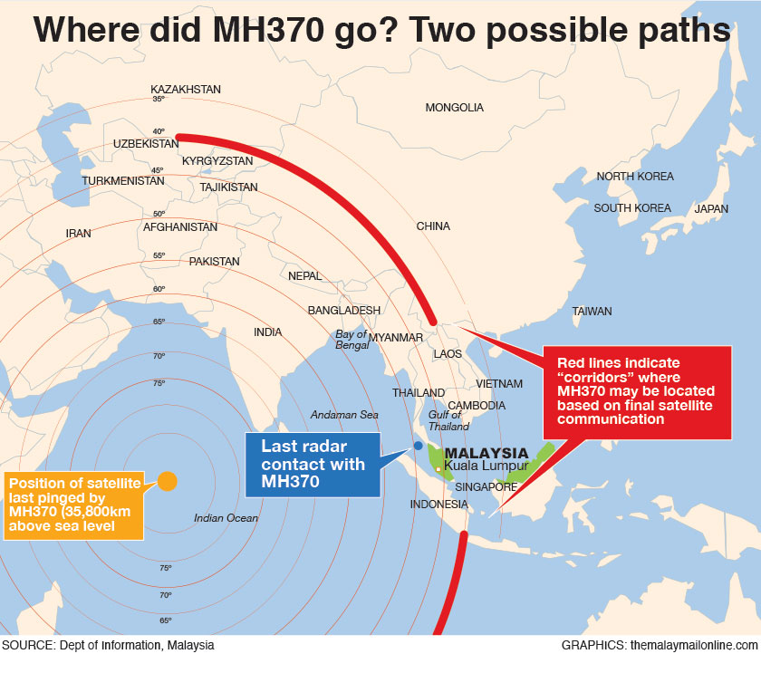
Yesterday, Malaysia revealed that satellite data has allowed investigators to arrive at two “corridors” where the plane could possibly be located: a northern arc from northern Thailand to the border of Kazakhstan and Turkmenistan in central Asia, or a southern one from Indonesia to the southern Indian Ocean.
While satellite information has provided investigators crucial clues about the Beijing-bound flight that disappeared on March 8 with 239 onboard — including that it flew on for hours more than previously believed — the two corridors thousands of kilometres apart had invited doubts over its accuracy.
One industry official explained that in the absence of critical location data, investigators were forced to extrapolate the possible location of MH370 relative to the Inmarsat satellite, based on its series of pings with craft in orbit.
The geostationary satellite orbiting the Earth at an altitude of 35,800km was pinged continually by MH370 after the last radar contact in the Straits of Malacca, which gave investigators a reference point to derive the additional details such as the jetliner’s last known heading, speed and likely fuel consumption.
The result is the two “corridors”: one to the north and another, which search teams are favouring, towards the south of the Indian Ocean.
Prime Minister Datuk Seri Najib Razak said yesterday new information showed that while the transponders and Aircraft Communications Addressing and Reporting System were turned off shortly into the flight, MH370 made a final satellite communication at 8.11am on March 8, nearly eight hours after it departed Kuala Lumpur International Airport.
“Due to the type of satellite data, we are unable to confirm the precise location of the plane when it last made contact with the satellite,” he said in his statement yesterday.
Based on the new data, the plane’s last communication with the satellite could be in either one of two locations, the “southern corridor” from Indonesia to the Indian Ocean off Australia or the “northern corridor” stretching from the borders of Kazakhstan and Turkmenistan to northern Thailand.
The northern option crosses heavily-militarised zones that made it unlikely that an unidentified aircraft the size of the Boeing 777 could have slipped past unnoticed. A defence industry executive said interceptors would have been deployed immediately once its presence was detected.


